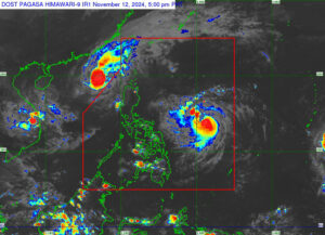
TROPICAL Storm Usagi, locally named Ofel, has entered the Philippine Area of Responsibility (PAR) and was set to make landfall over Northern or Central Luzon, the state weather bureau said on Tuesday.
“Regardless of the position of the landfall point, it must be emphasized that hazards on land and coastal waters may still be experienced in areas outside the landfall point or forecast confidence cone,” the Philippine Atmospheric, Geophysical and Astronomical Services Administration (PAGASA) said in a 5 p.m. bulletin.
Usagi was last seen 780 kilometers east of Virac, Catanduanes province, and it was moving west-northwestward at 30 kilometers per hour (kph). It was packing maximum sustained winds of 95 kph near the center and gustiness of up to 115 kph.
The weather bureau said Usagi had intensified into a severe tropical storm as it headed toward northern Philippines.
This comes after the area was battered by Typhoon Toraji (Nika), which left the Philippines at 2 p.m.
PAGASA said Usagi was expected to make landfall over the east coasts of Cagayan or Isabela province by Thursday (Nov. 14).
“Areas in Northern Luzon are at risk of heavy rainfall, severe wind and possibly, storm surge inundation from Ofel, which may cause considerable impacts,” it added.
It said provinces in Central and Southern Luzon might also be affected if the tropical cyclone further intensifies.
Separately, PAGASA was still monitoring Tropical Storm Man-Yi, which was last seen 2,515 kilometers east of Virac, Catanduanes province, and was traveling westward at 30 kph.
Man-Yi was packing maximum sustained winds of 75 kph near the center and gusts of up to 90 kph. Once it enters the PAR it will be named Pepito. — Adrian H. Alternate


